Now A Tropical Storm-Slowly Drifting North, Away From The Philippines
TROPICAL STORM LUPIT [RAMIL/22W/0920]
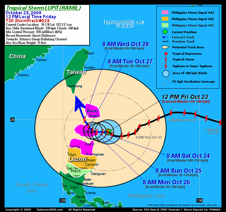
T2K PUBLIC ADVISORY NUMBER 029
6:00 PM PST (10:00 GMT) Fri 23 October 2009
Source: T2K ANALYSIS / JTWC WARNING #038
View: Advisory Archives (2004-2009)
--------------------------------------------------------------------------------
Tropical Storm LUPIT (RAMIL) has turned northward away from Cagayan's Coast during the past 3 hours and continues losing strength...threat to Extreme Northern Luzon diminishing.
*Residents and visitors along Extreme Northern Luzon, Okinawa-Ryukyu Islands, Taiwan & Southern Japan should closely monitor the progress of LUPIT (RAMIL).
*Kindly refer to your local warnings & bulletins issued by your country's official weather agency. This advisory is intended for additional information purposes only.
+ Forecast Outlook: LUPIT's forecast has changed...now gearing towards the Alternate Forecast Scenario...expected to drift slowly towards the north for the next 24 hours. The 2 to 5-day Long-Range Forecast shows LUPIT recurving to the NNE or NE slowly in the direction of Okinawa-Ryukyu Islands, as the steering high pressure ridge to its right becomes the dominant factor of pushing LUPIT poleward. The core shall be about 185 km. to the south of Okinawa, Japan on Wed Oct 28th as weakend tropical storm with winds of only 85 kph. Please be reminded that the Forecast Outlook changes every 6 hours, so a turn to the left or right of its future track and other conditions must be considered.
+ Effects: LUPIT's circulation has continued to weaken as strong dry air from the west affects the system. The core remains at sea, just east of Basco with its inner rainbands spreading across Batanes, Calayan Island and Cagayan. Light to moderate rains w/ tropical storm force winds not exceeding 85 kph can be expected along these bands. While the outer rainbands continues to affect the rest of Northern Luzon - where overcast skies along w/ light passing rains & gale-force winds not exceeding 60 kph can be expected. 24-hr total rainfall amounts of 25 to 200 mm (moderate to heavy rain) can be expected along its rainbands...with isolated amounts of 300 to 500 mm (very heavy to extreme rain) near the center of LUPIT. Click here to view the latest eTRaP graphic on the storm's rainfall amount. Residents in low-lying areas & steep slopes must remain alert & seek evacuation for possible life-threatening flash floods, mudslides & landslides due to the anticipated heavy rains brought about by this system. Precautionary measures must be initiated if necessary. Possible coastal Storm Surge flooding of 1 to 3 feet above normal tide levels...accompanied by large and dangerous battering waves...is possible along the coastal areas of Extreme Northern Luzon especially along Cagayan, Batanes-Calayan-Babuyan Island Group, Isabela & Ilocos Norte. Very minimal damage is likely on this type of storm surge. Danger from Rip Currents or Rip Tides can be expected along the beach-front areas of Northern Luzon & Taiwan.
[Important Note: Please keep in mind that the above forecast outlook, effects, current monsoon intensity, & tropical cyclone watch changes every 6 to 12 hrs!]
--------------------------------------------------------------------------------
Time/Date: 6:00 PM PST Fri October 23 2009
Location of Center: 19.9º N Lat 123.2º E Lon
Distance 1: 140 km (75 nm) ESE of Basco, Batanes
Distance 2: 190 km (103 nm) ENE of Calayan Island
Distance 3: 230 km (125 nm) NNE of Aparri, Cagayan
Distance 4: 300 km (162 nm) NNE of Tuguegarao City
Distance 5: 330 km (178 nm) NE of Laoag City
Distance 6: 630 km (340 nm) NNE of Metro Manila
Distance 7: 700 km (378 nm) North of Naga City
MaxWinds (1-min avg): 100 kph (55 kts) near the center
Peak Wind Gusts: 130 kph (70 kts)
24-hr Rain Amounts (near the center): 300-500 mm new!
Saffir-Simpson Typhoon Scale: Tropical Storm
Coastal Storm Surge Height: 1-3 feet [0.3-0.9 m]
Minimum Central Pressure: 982 millibars (hPa)
Recent Movement: Quasi-Stationary
Projected Area of Impact: Okinawa-Ryukyu Islands
Size (in Diameter): 890 km (480 nm) / Very Large
Max Sea Wave Height (near center): 31 ft (9.4 m)
PHILIPPINE STORM SIGNAL # THREE (3)
In Effect: BATANES GROUP, CAGAYAN, CALAYAN & BABUYAN ISLANDS, APAYAO, & ILOCOS NORTE.
PHILIPPINE STORM WARNING SIGNAL # TWO (2)
In Effect: -ILOCOS SUR, KALINGA, ISABELA, ABRA, & MT. PROVINCE.
The above areas will experience stormy weather today (with winds not exceeding 100 kph for #02 and more than 100 kph for #03). Coastal waters will be rough to very rough and extremely dangerous to all types of seacrafts.
PHILIPPINE STORM WARNING SIGNAL # ONE (1)
In Effect: LA UNION, BENGUET, IFUGAO, NUEVA VIZCAYA, QUIRINO & NORTHERN AURORA.
The above areas will have rains and winds of not more than 60 kph today. Coastal waters will be moderate to rough.
Residents living in low-lying and mountainous areas under Public Storm Warning Signal Numbers 3, 2 & 1 are alerted against flashfloods, mudflows, mudslides and landslides...while those living in coastal & beach-front areas are advised to seek higher grounds due to possible storm surge (aka. big waves) that could reach a high of 5 feet or more.