TYPHOON LUPIT [RAMIL/22W/0920]
T2K PUBLIC ADVISORY NUMBER 021
6:00 AM PST (22:00 GMT) Wed 21 October 2009
Source: T2K ANALYSIS / JTWC WARNING #028
View: Advisory Archives (2004-2009)
--------------------------------------------------------------------------------
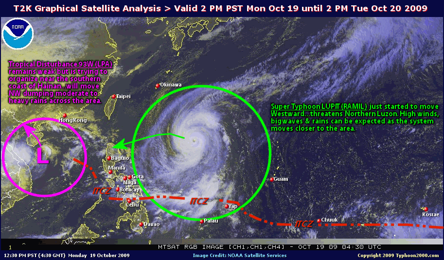
Typhoon LUPIT (RAMIL) has started moving slightly WSW-ward towards Extreme Northern Luzon...outer rainbands expected to reach the area tonight or tomorrow.
*Residents and visitors along Northern Luzon & Taiwan should closely monitor the progress of LUPIT (RAMIL).
*Kindly refer to your local warnings & bulletins issued by your country's official weather agency. This advisory is intended for additional information purposes only.
+ Forecast Outlook: LUPIT's forecast track has changed significantly with a much slower pace. The typhoon is now expected to decelerate as it tracks more WSW w/in the next 12 to 24 hours. Its wind speed will slightly strengthen back to Category 3 (185 kph) as it moves closer to Northern Luzon due to improved atmospheric conditions (warm ocean moisture & unstable air). The 2 to 5-day Long-Range Forecast shows LUPIT decelerating more as it approaches the northern coast of Cagayan on a WSW direction. LUPIT shall make landfall over the coast of Northern Ilocos Norte, near or over the town of Pagudpod early Sunday morning Oct 25 or approx. 2-3AM, & shall pass just to the north of Laoag City approx. 8-9 AM (Sun Oct 25). By early Monday morning, Oct 26, LUPIT shall be moving slowly across the South China Sea. *Alternate Forecast Scenario: There is a possibility that LUPIT might track Westward passing thru the Balintang Channel and spare Cagayan & Ilocos Norte from a direct hit, then move NW to Northward into Taiwan or SE China. This scenario is likely as some models deviates from the abovementioned forecast. The probability of this alternate forecast has increased, so a possible shift can happen. Please be reminded that the Forecast Outlook changes every 6 hours, so a turn to the left or right of its future track and other conditions must be considered.
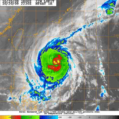
+ Effects: LUPIT's Eyewall Replacement Cycle has ended, now shows a large eyewall, with still a cloud-filled EYE...its over-all circulation has slightly improved. The outer & inner rain bands remains at sea...not yet affecting any major islands at this time. LUPIT may begin to affect Extreme Northern Luzon beginning tonight or tomorrow - if the forecast movement continues...deteriorating weather conditions expected. 1-day rainfall accumulations of 75 up to 200 mm (moderate to heavy rain) can be expected along its rainbands...with isolated accumulations of 400 mm or more (very heavy to extreme rain) near the center of LUPIT particularly along its projected path.
[Important Note: Please keep in mind that the above forecast outlook, effects, current monsoon intensity, & tropical cyclone watch changes every 6 to 12 hrs!]
--------------------------------------------------------------------------------
Time/Date: 6:00 AM PST Wed October 21 2009
Location of Eye: 20.3º N Lat 127.4º E Lon
Distance 1: 565 km (305 nm) East of Basco, Batanes
Distance 2: 645 km (350 nm) ENE of Aparri, Cagayan
Distance 3: 670 km (362 nm) NE of Tuguegarao City
Distance 4: 685 km (370 nm) NE of Ilagan City
Distance 5: 720 km (390 nm) NE of Casiguran, Aurora
Distance 6: 750 km (405 nm) ENE of Laoag City
Distance 7: 870 km (470 nm) NNE of Naga City
Distance 8: 920 km (497 nm) NE of Metro Manila
MaxWinds (1-min avg): 160 kph (85 kts) near the Eye
Peak Wind Gusts: 195 kph (105 kts)
Rainbands' Rain Rate: 2 to 30 mm/hr (.02 to 1.2 in/hr) new!
Saffir-Simpson Typhoon Scale: Category 2
Coastal Storm Surge Height: 6-8 feet [1.8-2.6 m]
Minimum Central Pressure: 959 millibars (hPa)
Recent Movement: WSW @ 15 kph (08 kts)
Projected Area of Impact: Extreme Northern Luzon
Size (in Diameter): 925 km (500 nm) / Very Large
Max Sea Wave Height (near center): 33 ft (10.0 m)